

The equipment we use and deploy to our surveys
- Timothy Rowley
- Nov 30, 2024
- 2 min read

STONEX X300 is a 3D scanner designed to deliver effective results every day, on any project. Its ease of use, reliability, flexibility, and reasonable price make it an ideal
companion for digitizing buildings. Data from the scanner is loaded directly into Recap® Pro. This scanner operates at 40,000 points per second with a maximum range
of 300m. It delivers 3D point cloud models to be used in AutoCAD.
£12,500 + VAT

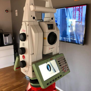
Total station Leica TS16 reflector less to 500m distance 5 second accuracy. This is used in conjunction with a Leica CS20 field control unit and captivate software.
Automatically and continuously adapts for best measurement performance to site conditions, such as rain, fog, dust, sun, heat shimmer and reflections Identifies
and ignores irrelevant targets and reflections with ATR plus to remain locked on your target, ignoring other distractions in the field Automated target aiming range with
accelerated target search with Power Search.
£28,794 + VAT

The GNSS / GPS equipment we use is the Comnav Sino GNSS. The T300 Plus GNSS Receiver features full-constellation multi-frequency tracking, with up to 65° tilt
compensation and an easy workflow with Android-based Survey Master software, for centimetre accuracy survey on demand. The T300 Plus tracks 965 channels with
all working and planned GNSS constellations including GPS, BDS, GLONASS, Galileo, QZSS, Navic and SBAS.
This works on a mobile VRS system and receives satellite and mobile correction data as well as GPS data from various base stations around the country. Accuracy is Dependent on conditions but is set to 12mm horizontal and 10mm vertical. This is a pay monthly subscription service £224+VAT per month.
£5500 + VAT

AutoCAD software equips architects, engineers, and construction professionals with precision tools to: Design and annotate 2D geometry and 3D models with solids,
surfaces and mesh objects. Automate drafting tasks to place objects with AI, compare drawings, create schedules, publish layouts, and more Maximise productivity with
customised workspaces.
£220+VAT monthly subscription
Recap Pro software helps designers and engineers capture high quality, detailed models of real-world assets. Use Recap Pro to: Understand and verify existing conditions
and as-built assets to gain insights and make better decisions. Deliver a point cloud or mesh in support of BIM (Building Information Modelling) processes and collaborate
across teams with real-world context. Survey, plan, construct, and renovate building and infrastructure projects.
£50 + VAT monthly subscription


Comments